


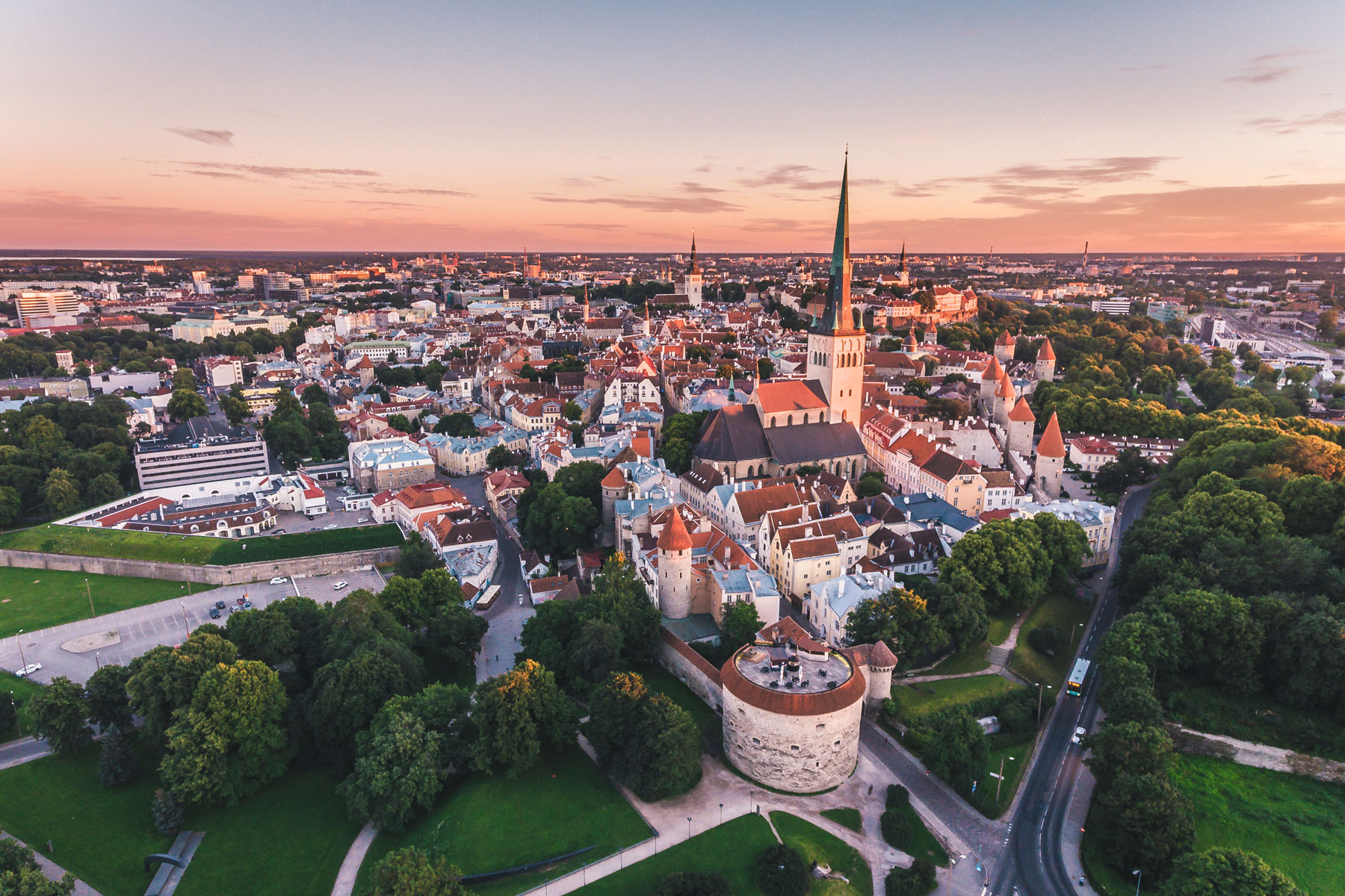
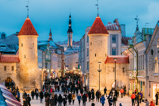
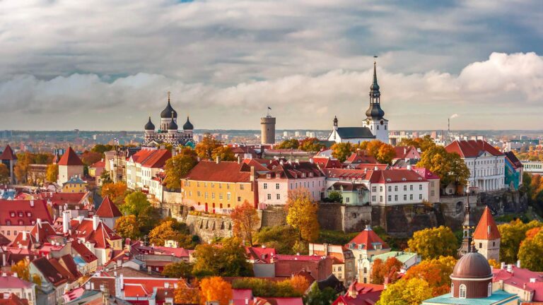
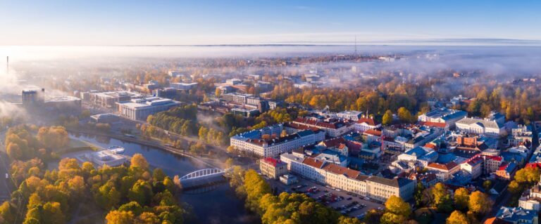
1. Tallinn
Tallinn is the most populous, primate, and capital city of Estonia. Situated on a bay in north Estonia, on the shore of the Gulf of Finland of the Baltic Sea, Tallinn has a population of 444,532 and administratively lies in the Harju maakond. Tallinn is the main financial, industrial, and cultural centre of Estonia. It is located 187 km northwest of the country’s second largest city Tartu, however only 80 km south of Helsinki, Finland, also 320 km west of Saint Petersburg, Russia, 300 km north of Riga, Latvia, and 380 km east of Stockholm, Sweden. From the 13th century until the first half of the 20th century, Tallinn was known in most of the world by variants of its other historical name Reval.
![fd3c2ae45324f6751fc7d3347191dbf4--old-town-watercolour[1]](https://hobbymart.net/wp-content/uploads/2022/05/fd3c2ae45324f6751fc7d3347191dbf4-old-town-watercolour1.jpg)
![AdobeStock_90380946[1]](https://hobbymart.net/wp-content/uploads/2022/05/AdobeStock_903809461-768x512.jpeg)
![old-tallinn-facts[1]](https://hobbymart.net/wp-content/uploads/2022/05/old-tallinn-facts1-768x307.jpg)
![image1_3[1]](https://hobbymart.net/wp-content/uploads/2022/05/image1_31-768x576.jpeg)


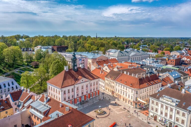
2. Tartu
Tartu is the second-largest city in Estonia, after the political and financial capital, Tallinn. It is 186 kilometres (116 miles) southeast of Tallinn and 245 kilometres (152 miles) northeast of Riga, the capital of Latvia. Tartu lies on the Emajõgi river, which connects the two largest lakes in Estonia, Lake Võrtsjärv and Lake Peipus. The city is served by Tartu Airport. Aerial view of Toomemägi, Tartu cathedral and Tartu downtown Tartu, the largest urban centre of southern Estonia, is often considered the "intellectual capital city" of the country, especially as it is home to the nation's oldest and most renowned university,
![social_1200_estonia-tartu-kissing-students[1]](https://hobbymart.net/wp-content/uploads/2022/05/social_1200_estonia-tartu-kissing-students1-768x401.jpg)
![2299_Tartu-Town-Hall_Riina-Varol_23093406-scaled[1]](https://hobbymart.net/wp-content/uploads/2022/05/2299_Tartu-Town-Hall_Riina-Varol_23093406-scaled1-768x506.jpg)
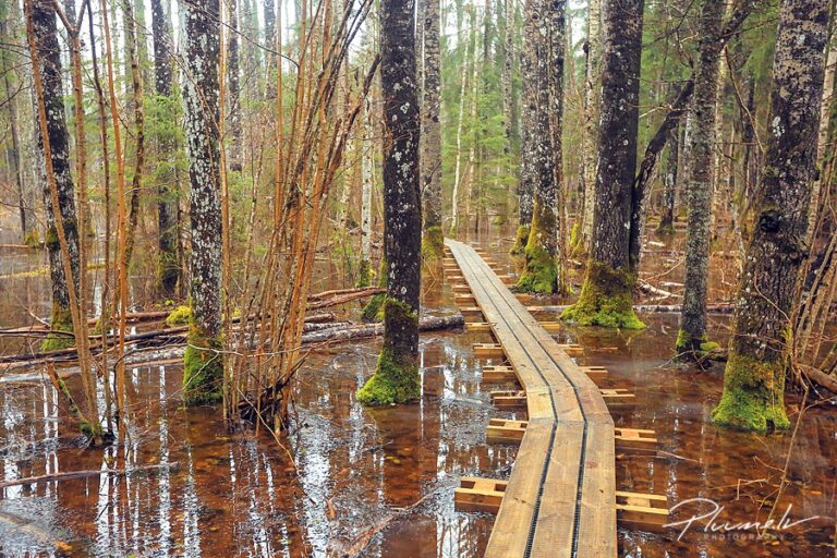
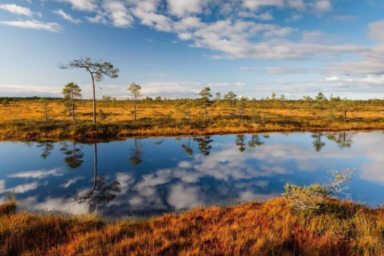
3. Lahemaa National Park
Lahemaa National Park is a park in northern Estonia, 70 kilometers east from the capital Tallinn. The Gulf of Finland is to the north of the park and the Tallinn-Narva highway (E20) is to the south. Its area covers 747 km2 (including 274.9 km2 of sea). It was the first area to be designated a national park of the former Soviet Union. It is the largest park in Estonia and one of Europe's biggest national parks. Its charter calls for the preservation, research and promotion of North-Estonian landscapes, ecosystems, biodiversity and national heritage.
![lahemaa-national-park_1_viru-bog-lahemaa-national-park[1]](https://hobbymart.net/wp-content/uploads/2022/05/lahemaa-national-park_1_viru-bog-lahemaa-national-park1-768x511.jpg)
![15544220097_b175b3330c_k[1]](https://hobbymart.net/wp-content/uploads/2022/05/15544220097_b175b3330c_k1-768x513.jpg)
![49408dce485eb22ccb4faf0bdef00993[1]](https://hobbymart.net/wp-content/uploads/2022/05/49408dce485eb22ccb4faf0bdef009931-768x512.jpg)
![lahemaa-national-park[1]](https://hobbymart.net/wp-content/uploads/2022/05/lahemaa-national-park1-768x402.jpg)

4. Saaremaa
Saaremaa is the largest island in Estonia, measuring 2,673 km2 (1,032 sq mi). The main island of Saare County, it is located in the Baltic Sea, south of Hiiumaa island and west of Muhu island, and belongs to the West Estonian Archipelago. The capital of the island is Kuressaare, which in January 2018 had 13,276 inhabitants. The whole island had a recorded population in January 2020 of 31,435.
![europe_estonia_saarema_island_angla_windmills_banner-narrow[1]](https://hobbymart.net/wp-content/uploads/2022/05/europe_estonia_saarema_island_angla_windmills_banner-narrow1-768x384.jpg)

![irra_irra[1]](https://hobbymart.net/wp-content/uploads/2022/05/irra_irra1-768x514.jpg)

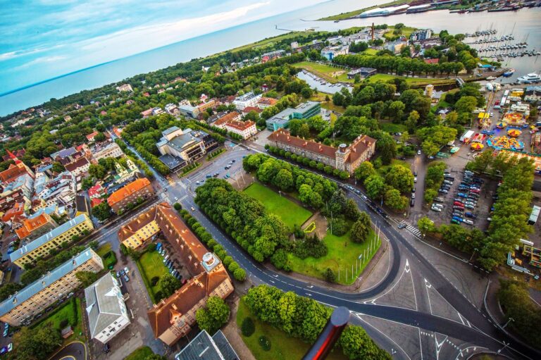
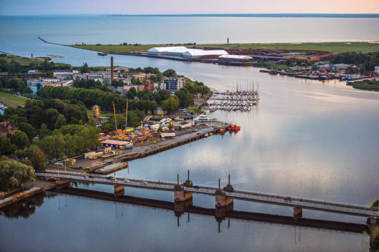
5. Parnu
Pärnu is the fourth largest city in Estonia. Situated in southwest Estonia, Pärnu is located 128 kilometres (80 mi) south of the Estonian capital, Tallinn, and 176 kilometres (109 mi) west of Estonia's second largest city, Tartu. The city sits off the coast of Pärnu Bay, an inlet of the Gulf of Riga, which is a part of the Baltic Sea. In the city, the Pärnu River drains into the Gulf of Riga. Pärnu is a popular summer holiday resort town among Estonians with many hotels, restaurants and large beaches. The city is served by Pärnu Airport.
![architecture-parnu-estonia-january-architectural-diversity-centre-resort-estonian-town-historic-brick-buildings-82658422[1]](https://hobbymart.net/wp-content/uploads/2022/05/architecture-parnu-estonia-january-architectural-diversity-centre-resort-estonian-town-historic-brick-buildings-826584221-768x515.jpg)
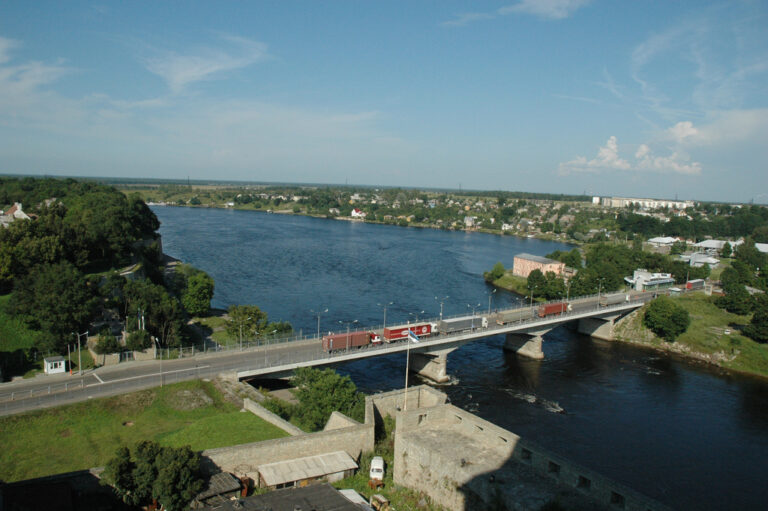
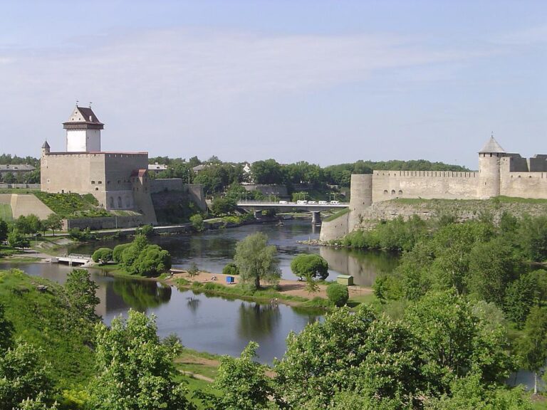
6. Narva Castle
More than 700 years old, Hermann Castle in Narva has been ruled over by Danes, Germans, Swedes and Russians through the centuries, but now finally belongs to Estonians. It obtained its current appearance during the time of the Livonian Order from the 14th-16th centuries. Badly damaged in the Second World War, the castle was significantly restored in the 1970 and 1980s before opening as a museum, which simultaneously offered a permanent exhibition showcasing the history of Narva as well as almost a dozen temporary exhibitions.
![67506bb2-831b-447a-96a8-fd29d88efb10-istock-1132342065[1]](https://hobbymart.net/wp-content/uploads/2022/05/67506bb2-831b-447a-96a8-fd29d88efb10-istock-11323420651-768x509.jpg)
![Narva-Hermanni-Linnus-34[1]](https://hobbymart.net/wp-content/uploads/2022/05/Narva-Hermanni-Linnus-341-768x553.jpg)
![narva-castle-estonian-summer-36290809[1]](https://hobbymart.net/wp-content/uploads/2022/05/narva-castle-estonian-summer-362908091-768x512.jpg)

7. Hiiumaa
Hiiumaa is the second largest island in Estonia and is part of the West Estonian archipelago, in the Baltic Sea. It has an area of 989 km2 and is 22 km from the Estonian mainland. Its largest town is Kärdla. It is located within Hiiu County.
![Estonia4[1]](https://hobbymart.net/wp-content/uploads/2022/05/Estonia41-768x529.jpg)
![tahkuna2[1]](https://hobbymart.net/wp-content/uploads/2022/05/tahkuna21-768x512.jpg)
![DSC_7716_large[1]](https://hobbymart.net/wp-content/uploads/2022/05/DSC_7716_large1-768x512.jpg)
8. Rakvere Castle
Northern Estonia is home to Rakvere, a city where humans have lived for nearly 1,500 years. The city’s biggest attractions is Rakvere Castle, which was constructed in the 16th century. The castle has become a kind of medieval theme park, and costumed visitors and staff wander the grounds. You can watch knights polishing their armor, see an alchemist’s workshop and tour the ancient wine cellar. In the castle’s Shenkenberg Tavern, you can even dine on classic medieval dishes. Visiting the castle is an unforgettable way to bring history to life.
![800px-Rakvere-castle-estonia-cropped[1]](https://hobbymart.net/wp-content/uploads/2022/05/800px-Rakvere-castle-estonia-cropped1-768x504.jpg)
![IMG_8480[1]](https://hobbymart.net/wp-content/uploads/2022/05/IMG_84801-768x512.jpg)
![Rakvere_stronghold[1]](https://hobbymart.net/wp-content/uploads/2022/05/Rakvere_stronghold1.jpg)
![tumblr_nvi60xyQ7d1qaqcx8o1_1280[1]](https://hobbymart.net/wp-content/uploads/2022/05/tumblr_nvi60xyQ7d1qaqcx8o1_12801-768x527.jpg)
9. Soomaa National Park
Soomaa National Park is a national park in south-western Estonia. Soomaa ("land of bogs") protects 390 km², the park was created in 1993. Soomaa is Important Bird Area since 1989 and a Ramsar site of protected wetlands since 1997 and a Natura 2000 area since 2004.
![6e5307df-2da3-4841-ba31-613daf829571-soomaa-national-park[1]](https://hobbymart.net/wp-content/uploads/2022/05/6e5307df-2da3-4841-ba31-613daf829571-soomaa-national-park1-768x432.jpg)
![soomaa_navesti[1]](https://hobbymart.net/wp-content/uploads/2022/05/soomaa_navesti1-768x512.jpg)

10. Viljandi
Viljandi is a town and municipality in southern Estonia with a population of 17,407 in 2019. It is the capital of Viljandi County and is geographically located between two major Estonian cities, Pärnu and Tartu. The town was first mentioned in 1283, upon being granted its town charter by Wilhelm von Endorpe. The town became a member of the Hanseatic League at the beginning of the 14th century, and is one of five Estonian towns and cities in the league. The once influential Estonian newspaper Sakala was founded in Viljandi in 1878.
![1200x630px-Viljandi_Castle_1[1]](https://hobbymart.net/wp-content/uploads/2022/05/1200x630px-Viljandi_Castle_11-768x403.jpg)
![maxresdefault[1]](https://hobbymart.net/wp-content/uploads/2022/05/maxresdefault1-16-768x432.jpg)
![1600_900_false_false_b753e748b0495a74e6ad9b0681709187[1]](https://hobbymart.net/wp-content/uploads/2022/05/1600_900_false_false_b753e748b0495a74e6ad9b06817091871-768x432.jpg)
![c36ff1ecd5098864bafbe52e75ed818f[1]](https://hobbymart.net/wp-content/uploads/2022/05/c36ff1ecd5098864bafbe52e75ed818f1.jpg)