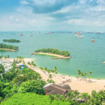
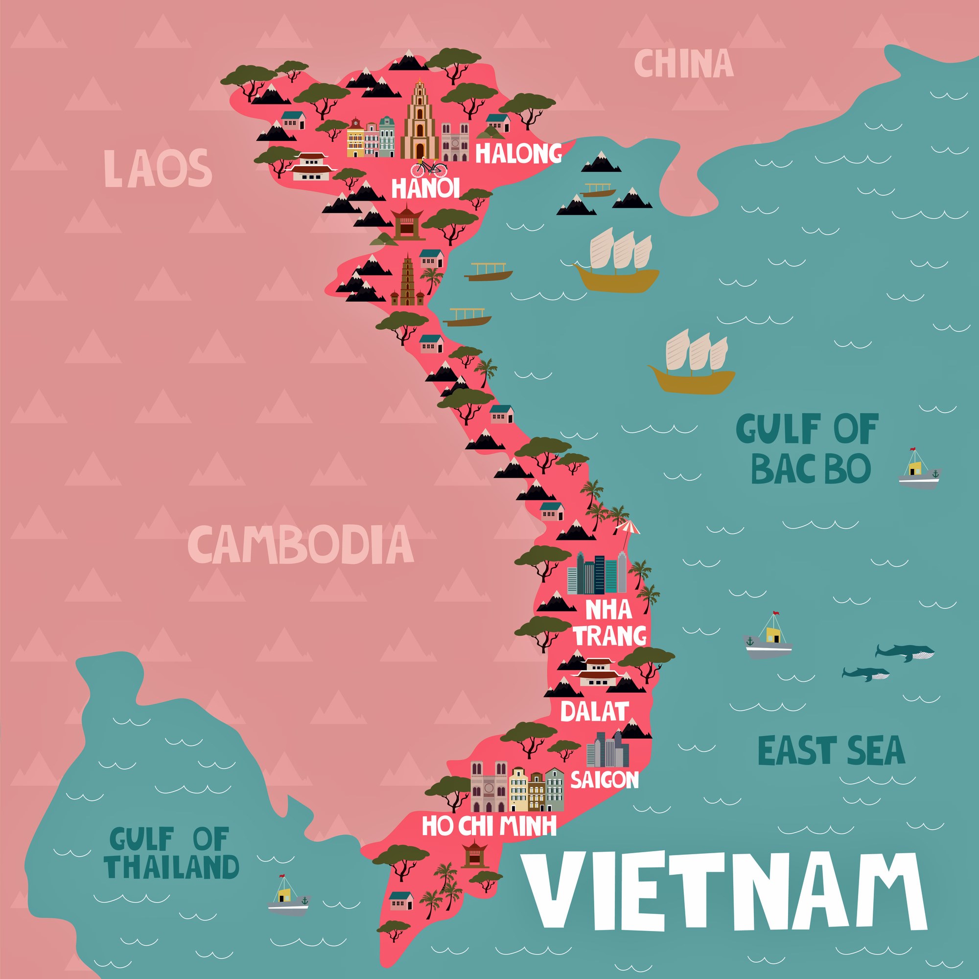

1. Halong Bay
Hạ Long Bay or Halong Bay is a UNESCO World Heritage Site and popular travel destination in Quảng Ninh Province, Vietnam. The name Hạ Long means "descending dragon". Administratively, the bay belongs to Hạ Long city, Cẩm Phả city, and is a part of Vân Đồn District. The bay features thousands of limestone karsts and isles in various shapes and sizes. Ha Long Bay is a center of a larger zone which includes Bai Tu Long Bay to the northeast, and Cát Bà Island to the southwest. These larger zones share a similar geological, geographical, geomorphological, climate, and cultural characters.
![halongbay[1]](https://hobbymart.net/wp-content/uploads/2022/04/halongbay1-768x512.jpg)
![5d4411510e5f8[1]](https://hobbymart.net/wp-content/uploads/2022/04/5d4411510e5f81-768x432.jpg)
![Halong-bay-59-1920x1440[1]](https://hobbymart.net/wp-content/uploads/2022/04/Halong-bay-59-1920x14401-1-768x576.jpg)
![ammie-ngo-690967-unsplash[1]](https://hobbymart.net/wp-content/uploads/2022/04/ammie-ngo-690967-unsplash1-768x512.jpg)

2. Ho Chi Minh City
Ho Chi Minh City is the largest city in Vietnam. Located in Southern Vietnam, the city surrounds the Saigon River and covers about 2,061 km2 (796 sq mi).
![spring-Ho-Chi-Minh-city-vietnam[1]](https://hobbymart.net/wp-content/uploads/2022/04/spring-Ho-Chi-Minh-city-vietnam1-768x443.jpg)

![ho-chi-minh-city-overview-at-night[1]](https://hobbymart.net/wp-content/uploads/2022/04/ho-chi-minh-city-overview-at-night1-768x384.jpg)
![banner20-20ho_chi_minh_tcm36-52256[1]](https://hobbymart.net/wp-content/uploads/2022/04/banner20-20ho_chi_minh_tcm36-522561-768x288.jpg)
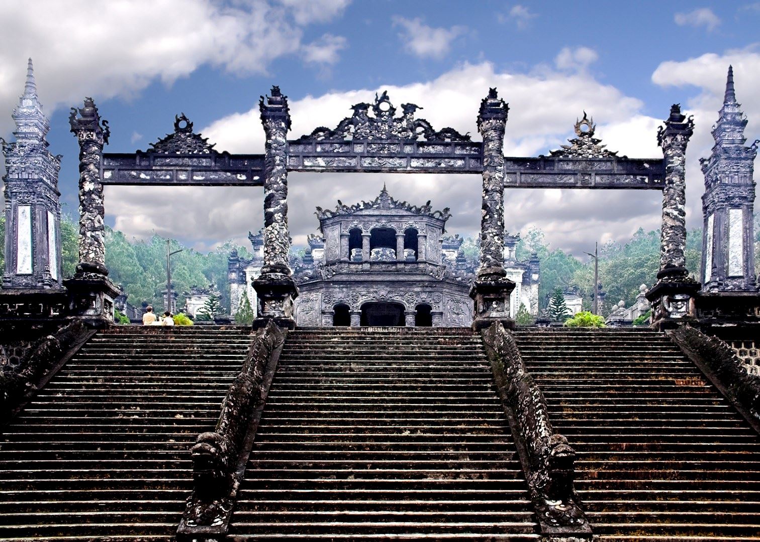
3. Hue
Huế is the capital of Thừa Thiên Huế Province in central Vietnam and was the capital of Đàng Trong from 1738 to 1775 and of Vietnam during the Nguyễn Dynasty from 1802 to 1945. The city served as the administrative capital for the Nguyễn dynasty, and later functioned as the administrative capital of the protectorate of Annam during the French Indochina period.
![1-imperial-city-citadel-hue-vietnam-maps-address-opening-hours-guide-hue-tourist-attractions-3[1]](https://hobbymart.net/wp-content/uploads/2022/04/1-imperial-city-citadel-hue-vietnam-maps-address-opening-hours-guide-hue-tourist-attractions-31-768x511.jpg)
![hue-3707206_1280-1-1024x652[1]](https://hobbymart.net/wp-content/uploads/2022/04/hue-3707206_1280-1-1024x6521-1-768x489.jpg)
![1280px-Hue_Vietnam_Tomb-of-Emperor-Minh-Mang-01[1]](https://hobbymart.net/wp-content/uploads/2022/04/1280px-Hue_Vietnam_Tomb-of-Emperor-Minh-Mang-011-768x512.jpg)
![Vietnam-Hue-8_c68cf[1]](https://hobbymart.net/wp-content/uploads/2022/04/Vietnam-Hue-8_c68cf1-768x480.jpg)
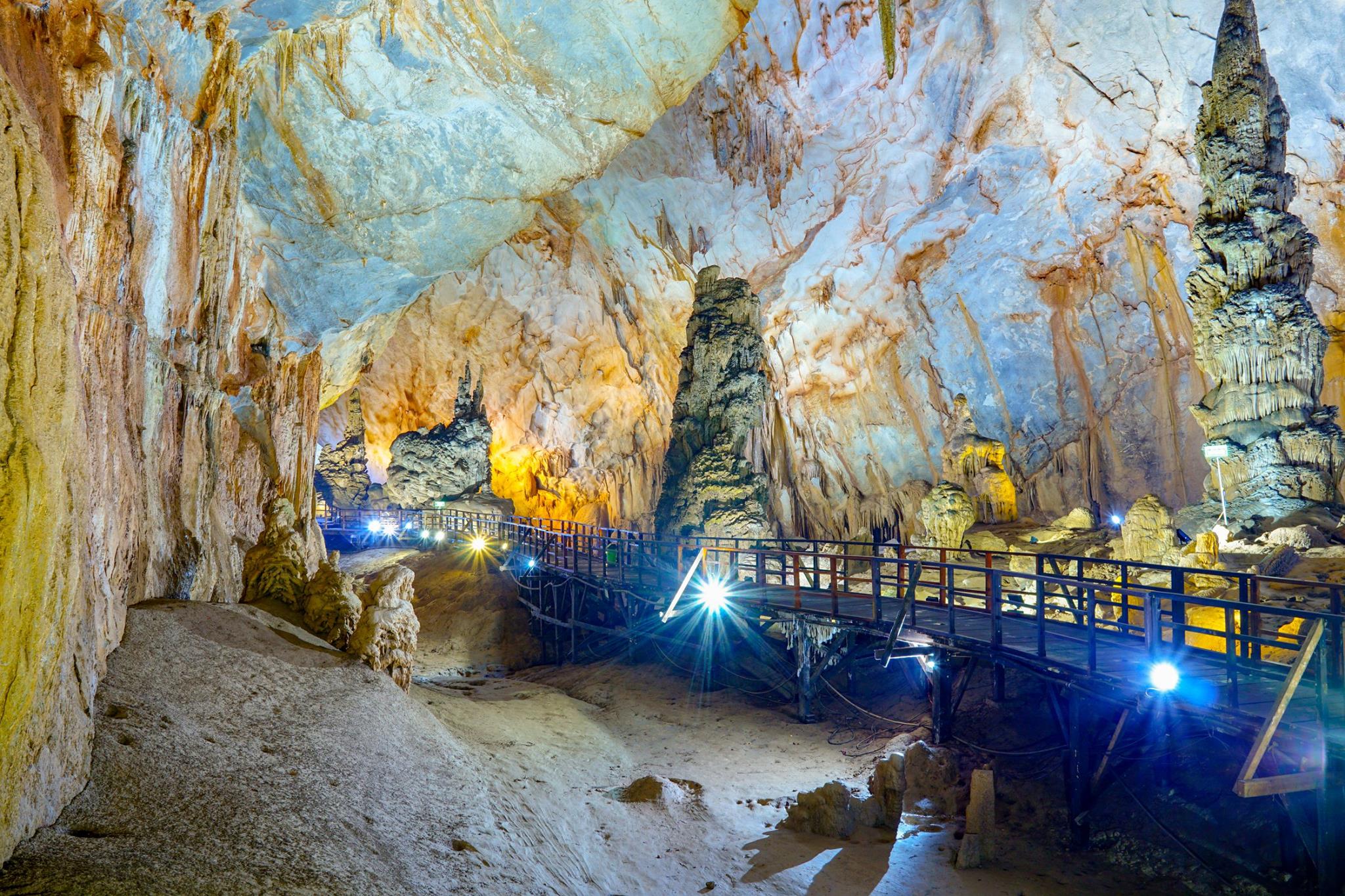
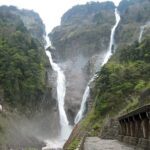
4. Phong Nha-Ke Bang National Park
Phong Nha-Kẻ Bàng is a national park and UNESCO World Heritage Site in the Bố Trạch and Minh Hóa districts of central Quảng Bình Province in the North Central Coast region of Vietnam, about 500 km south of Hanoi. The park borders the Hin Namno National Park in Khammouane Province, Laos to the west and 42 km east of the South China Sea from its borderline point. Phong Nha-Kẻ Bàng National Park is in a limestone zone of 2,000 km2 in Vietnamese territory and borders another limestone zone of 2,000 km2 of Hin Namno in Laotian territory. The core zone of this national park covers 857.54 km2 and a buffer zone of 1,954 km2.
![73958445[1]](https://hobbymart.net/wp-content/uploads/2022/04/739584451-768x512.jpg)
![quang-binh-phong-nha-cave-4[1]](https://hobbymart.net/wp-content/uploads/2022/04/quang-binh-phong-nha-cave-41-768x506.jpg)
![phong-nha-ke-bang-national-park-04-efe5b0df-85a5-4df0-9e2c-ecc1be09c063[1]](https://hobbymart.net/wp-content/uploads/2022/04/phong-nha-ke-bang-national-park-04-efe5b0df-85a5-4df0-9e2c-ecc1be09c0631-768x513.jpg)
![istock497971346_vietnam_phong_nha_ke_bang[1]](https://hobbymart.net/wp-content/uploads/2022/04/istock497971346_vietnam_phong_nha_ke_bang1-768x256.jpg)
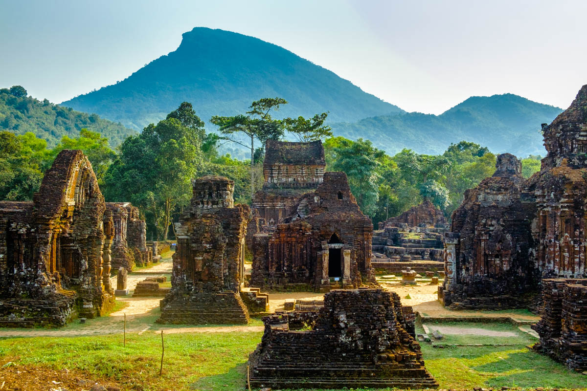
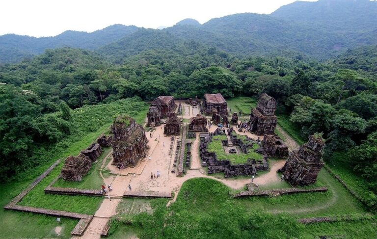
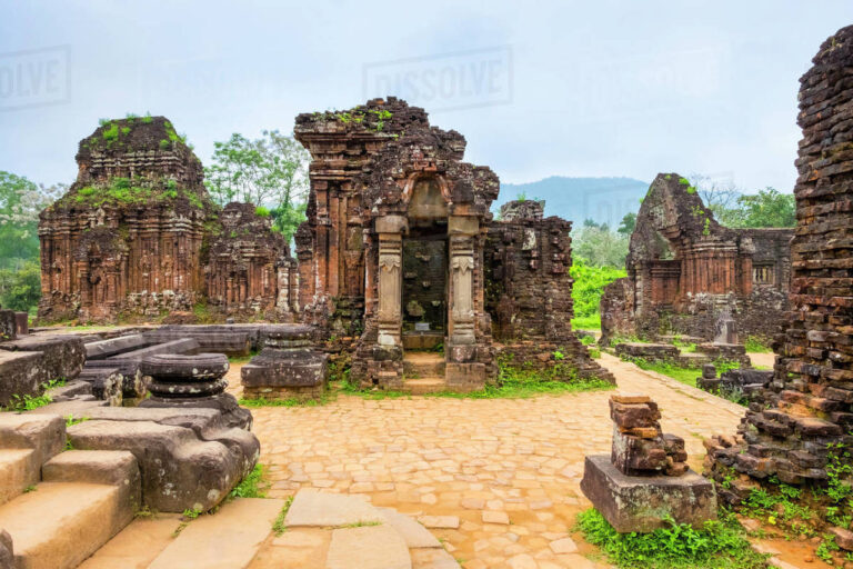
5. My Son
Mỹ Sơn is a cluster of abandoned and partially ruined Hindu temples in central Vietnam, constructed between the 4th and the 14th century by the Kings of Champa, an Indianized kingdom of the Cham people. The temples are dedicated to the worship of the god Shiva, known under various local names, the most important of which is Bhadreshvara. Mỹ Sơn is located near the village of Duy Phú, in the administrative district of Duy Xuyên in Quảng Nam Province in Central Vietnam, 69 km southwest of Da Nang, and approximately 10 km from the historic Champa capital of Trà Kiệu. The temples are in a valley roughly two kilometres wide that is surrounded by two mountain ranges.
![532839-my-son-ruins-near-hoi-an[1]](https://hobbymart.net/wp-content/uploads/2022/04/532839-my-son-ruins-near-hoi-an1-768x549.jpg)
![DSC_0583-min-min[1]](https://hobbymart.net/wp-content/uploads/2022/04/DSC_0583-min-min1-768x511.jpg)
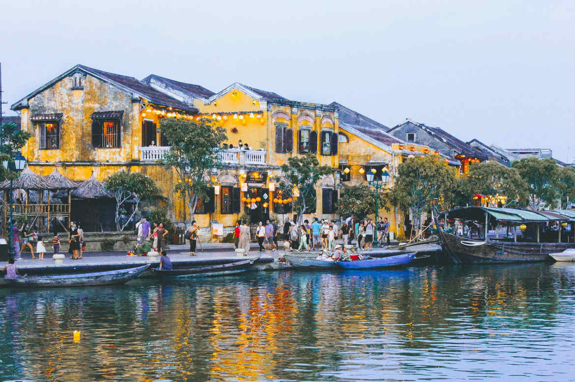
6. Hoi An
Hội An, formerly known as Fai-Fo or Faifoo, is a city with a population of approximately 120,000 in Vietnam's Quảng Nam Province and is noted as a UNESCO World Heritage Site since 1999. Along with the Cu Lao Cham archipelago, it is part of the Cu Lao Cham-Hoi An Biosphere Reserve, designated in 2009. Old Town Hội An, the city's historic district, is recognized as an exceptionally well-preserved example of a Southeast Asian trading port dating from the 15th to the 19th century, its buildings and street plan reflecting a blend of indigenous and foreign influences. Prominent in the city's old town is its covered "Japanese Bridge", dating to the 16th–17th century.
![GettyImages-459301061-57b6d0de3df78c876340214e[1]](https://hobbymart.net/wp-content/uploads/2022/04/GettyImages-459301061-57b6d0de3df78c876340214e1-768x512.jpg)
![street-hoi-an-vietnam-shutterstock_1063328627[1]](https://hobbymart.net/wp-content/uploads/2022/04/street-hoi-an-vietnam-shutterstock_10633286271-768x512.jpg)
![shutterstock_1303493764[1]](https://hobbymart.net/wp-content/uploads/2022/04/shutterstock_13034937641-768x512.png)
![destination-hoi-an-vietnam[1]](https://hobbymart.net/wp-content/uploads/2022/04/destination-hoi-an-vietnam1-768x336.jpg)

7. Sapa Countryside
The verdant rice field countryside surrounding Sapa, bordered by the jagged peaks of the Hoang Lien Mountains (often still known by their French colonial era name of the Tonkinese Alps), are home to Vietnam's most beautiful rural vistas. The deep valleys here are home to a diverse mix of the country's ethnic minorities, including the Hmong, Giay, and Red Dzao people, while the rippling hills are terraced with rice fields and overlooked by the country's tallest peak, Fansipan Mountain. This is the top trekking destination in Vietnam with oodles of options to trek or day hike between tiny villages and experience the staggering mountain views. Sapa itself is the main base here - an old hill station and now a bustling and forever growing tourist center that is a stark contrast to the sumptuous tranquil countryside right on its doorstep.
![980x[1]](https://hobbymart.net/wp-content/uploads/2022/04/980x1-768x431.jpg)
![VietnamPrint-1-15-1024x683[1]](https://hobbymart.net/wp-content/uploads/2022/04/VietnamPrint-1-15-1024x6831-1-768x512.jpg)
![Sapa-Countryside-1[1]](https://hobbymart.net/wp-content/uploads/2022/04/Sapa-Countryside-11-768x576.jpg)
![landscape-view-sapa-valley-lao-cai-province-vietnam-northwest-161665498[1]](https://hobbymart.net/wp-content/uploads/2022/04/landscape-view-sapa-valley-lao-cai-province-vietnam-northwest-1616654981-768x513.jpg)
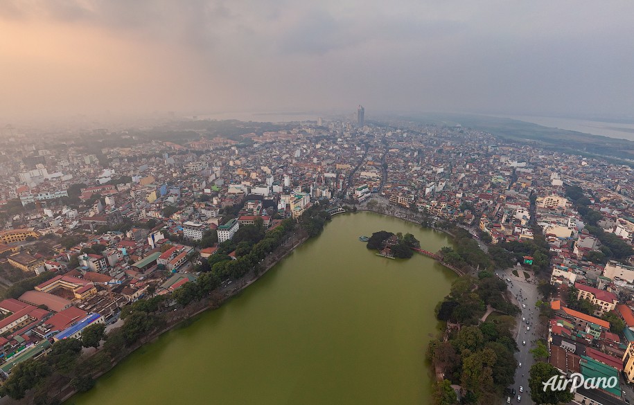
8. Hanoi
Hanoi is the capital city of Vietnam. It covers an area of 3,358.6 km2 (1,296.8 sq mi). The second largest city in Vietnam, it consists of 12 urban districts, 1 district-leveled town and 17 rural districts. Located within the Red River Delta, Hanoi is the cultural and political centre of Vietnam.
![golden_bridge_vietnam_cover[1]](https://hobbymart.net/wp-content/uploads/2022/03/golden_bridge_vietnam_cover1-768x320.jpg)
![VGPC_1582704740_DJI_0305-1200x675[1]](https://hobbymart.net/wp-content/uploads/2022/04/VGPC_1582704740_DJI_0305-1200x6751-1-768x432.jpg)
![Hanoi-Vietnam[1]](https://hobbymart.net/wp-content/uploads/2022/04/Hanoi-Vietnam1-768x432.jpg)
![1511791078990[1]](https://hobbymart.net/wp-content/uploads/2022/04/15117910789901.jpg)

9. Nha Trang
Nha Trang is a coastal city and capital of Khánh Hòa Province, on the South Central Coast of Vietnam. It is bounded on the north by Ninh Hoà town, on the south by Cam Ranh city and on the west by Diên Khánh District. The city has about 392,000 inhabitants, a number that is projected to increase to 560,000 by 2015 and 630,000 inhabitants by 2025. An area of 12.87 km2 (4.97 sq mi) of the western communes of Diên An and Diên Toàn is planned to be merged into Nha Trang which will make its new area 265.47 km2 (102.50 sq mi) based on the approval of the Prime Minister of Vietnam in September 2012.
![Nha-Trang_15-1024x576[1]](https://hobbymart.net/wp-content/uploads/2022/04/Nha-Trang_15-1024x5761-1-768x432.jpg)
![Tran-Phu-Beach-nha-trang[1]](https://hobbymart.net/wp-content/uploads/2022/04/Tran-Phu-Beach-nha-trang1-768x382.jpg)
![whattodoinnhatrang_6[1]](https://hobbymart.net/wp-content/uploads/2022/04/what20to20do20in20nha20trang_61-768x415.jpg)
![nha-trang-travel-vietnam_2019-05-20_567[1]](https://hobbymart.net/wp-content/uploads/2022/04/nha-trang-travel-vietnam_2019-05-20_5671-768x443.jpg)
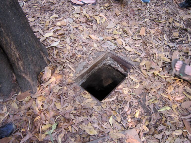
10. Cu Chi Tunnels
The tunnels of Củ Chi are an immense network of connecting tunnels located in the Củ Chi District of Ho Chi Minh City (Saigon), Vietnam, and are part of a much larger network of tunnels that underlie much of the country. The Củ Chi tunnels were the location of several military campaigns during the Vietnam War, and were the Viet Cong's base of operations for the Tết Offensive in 1968.
![Cu-Chi-Tunnels-Trap[1]](https://hobbymart.net/wp-content/uploads/2022/04/Cu-Chi-Tunnels-Trap1-768x512.jpg)
![dsc_0077[1]](https://hobbymart.net/wp-content/uploads/2022/04/dsc_00771-768x512.jpg)
![Cu_Chi_Tunnels_09[1]](https://hobbymart.net/wp-content/uploads/2022/04/Cu_Chi_Tunnels_091-768x576.jpg)

11. Ba Be National Park
Ba Bể National Park (Vietnamese: Vườn Quốc Gia Ba Bể) is a reserve in Bắc Kạn Province, Northeast region of Vietnam, set up to protect a very murky lake (Ba Bể Lake) along with surrounding limestone and highland nevergreen forests. It is located about 240 kilometers northwest of the capital city Hanoi.
12. Mekong Delta
The Mekong Delta (Vietnamese: Đồng bằng Sông Cửu Long, literally Nine Dragon river delta or simply Vietnamese: Đồng Bằng Sông Mê Kông, "Mekong river delta"), also known as the Western Region (Vietnamese: Miền Tây) or South-western region (Vietnamese: Tây Nam Bộ), is the region in southwestern Vietnam where the Mekong River approaches and empties into the sea through a network of distributaries. The Mekong delta region encompasses a large portion of southwestern Vietnam of over 40,500 square kilometres (15,600 sq mi).[2] The size of the area covered by water depends on the season. Its wet coastal geography makes it an important source of agriculture and aquaculture for the country.

13. Cat Ba Island
Cát Bà Island is the largest of the 367 islands spanning 260 km2 (100 sq mi) that comprise the Cat Ba Archipelago, which makes up the southeastern edge of Lan Ha Bay in Northern Vietnam. Cat Ba island has a surface area of 285 km2 (110 sq mi) and maintains the dramatic and rugged features of Ha Long Bay.

14. Ha Giang
Hà Giang is a city located on the banks of the Lô River in the Northeast region of Vietnam. It is the capital of Hà Giang Province. The city has an area of 135.33 km2 and a population of 55 559 inhabitants. The population is composed of 22 different ethnicities, of which 55.7% are Kinh and Tày people.
15. Phu Quoc Island
Phú Quốc (Vietnamese: [fǔ kǔə̯k]) is the largest island in Vietnam. Phú Quốc and nearby islands, along with the distant Thổ Chu Islands, are part of Kiên Giang Province as Phú Quốc City, the island has a total area of 574 km2 (222 sq mi) and a permanent population of approximately 179,480 people. Located in the Gulf of Thailand, the island city of Phú Quốc includes the island proper and 21 smaller islets. Dương Đông ward is located on the west coast, and is also the administrative and largest town on the island. The other ward is An Thới on the southern tip of the island.

16. Con Dao Islands
The Côn Đảo ("Côn Island") are an archipelago of Bà Rịa–Vũng Tàu province, in the Southeast region of Vietnam, and also a district (Vietnamese: Huyện Côn Đảo, lit. 'Côn Đảo district') of this province.
17. Mui Né
Mũi Né is a coastal fishing town in the south-central Bình Thuan Province of Vietnam. The town, with approximately 25,000 residents, is a ward of the city of Phan Thiết. Mui Ne and the other wards of Phan Thiet stretch along the coast for approximately 50 kilometers and have been transformed into a resort destination since the mid 1990s, when many visited the area to view the solar eclipse of October 24, 1995. Most notably, tourism has developed in the area from the Phan Thiet city center to Mui Ne, which has more than a hundred beach resorts, as well as restaurants, bars, shops and cafes. Mũi Né ward has two beaches; Ganh Beach and Suoi Nuoc Beach, both with a number of resorts and a few shops and restaurants. But the most highly developed area is Rang Beach in Ham Tien ward (often erroneously called "Mui Ne Beach" by foreigners), which extends west of Mui Ne.